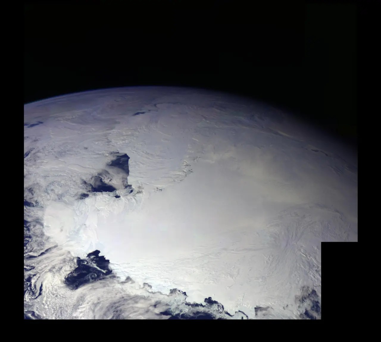
Above is a composite picture of the entire Antarctic continent assembled from pictures taken by NASA’s Galileo space probe in 1990. It shows no evidence of a giant ice wall preventing explorers from reaching the South Pole as alleged by many in the Flat Earth believing asylum. But Flat Earthers also say nothing NASA produces can be trusted.

As a result I decided to have a look on the Internet to see if I could find maps of Antarctica created pre-1950. That would mean they were created before the era of space flight and satellites. I found several such images showing the whole continent but the images are largely from companies like iStock and are subject to copyright hence I cannot reproduce them here. You can easily do an image search yourself.

However looking further back I was able to find pre-1900 images in Atlases, which show maps of the whole spherical Earth including the Antarctic continent. The Atlas shown here, Illustrirter Hand-Atlas der Geographie und Statistik was edited by Traugott Bromme and published by Krais & Hoffmann in 1862 in the German language.

This means that before 1900 there were many cartographers who created maps of the whole world, including the Antarctic continent, from the records of sailors who mapped the land masses and islands of the seas. No Flat Earth is shown with an ice wall in the South. The only thing flat are the pages the maps are printed on, where a projection is used to put a spherical planet onto a flat page.
So what is the big deal of a spherical Earth? Why are Flat Earth believers so fearful of the sphere? Like they say “There is nothing to fear but the sphere itself”.
Physics of the Sphere
On the Internet people argue that buildings seen using a powerful Nikon camera across a body of water, for example, Chicago seen across Lake Michigan, prove the Earth is flat.
Unfortunately over water there are also mirage effects where light is bent across the surface of the water due to varying temperatures as a function of height in the atmosphere causing a lensing effect.
Sometimes people show images of a ship which is partially below the horizon at some distance from the viewer and this is meant to disprove the spherical shape of Earth. It actually illustrates the opposite, that the ocean lays across a spherical surface.

This is a good example which actually indicates the spherical nature of the surface of the ocean. The background ship is sunken below the visible horizon. Shipping containers stacked up on its deck are seen but not the hull of the ship. Clearly it is contrasted with the foreground ship, which is seen sitting in the water because it is much closer. This is easily explained.
First let’s start with the geometry of the sphere.

Using Fig. 1, imagine you are standing at sea level and you have a height of h (from your feet to your eyes) and you are looking across the ocean and see the point just at your horizon of a building (or ship) of height t above sea level at a distant location. The building (or ship) could be higher than t but that is its point you can just see above your horizon from where you stand. If the building (or ship) cannot be seen then it is below your horizon, as illustrated by the hull of the more distant ship in the image above.
You know from measurements (could be using a laser ranging device) the distance to the the building (or ship) you see. In Fig. 1 it is described as d + D. The distance d is from your eye to where a straight line just touches the surface of the ocean, i.e it is tangent to it, and the distance D is from that same point to the point of the building (or ship) just appearing above the surface of the ocean, your horizon.
Distance d depends on your height and distance D depends on the height of the building (or ship) above sea level.
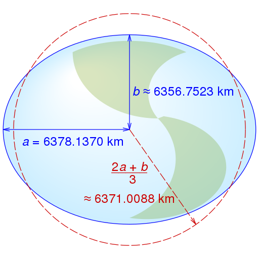
The earth’s radius is denoted as R in Fig. 1. Our planet is a spheroid, actually an oblate ellipsoid with a tidal bulge at the equator due to the rapid rotation of the planet. Thus its radius ranges from a maximum equatorial radius of nearly a = 6,378 km (3,963 mi) to a minimum polar radius of nearly b = 6,357 km (3,950 mi) as shown in Fig. 2. See below.
From basic geometry of Pythagoras, using Fig. 1, we can write down the following equations.
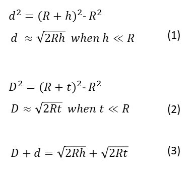
Since your height h above sea level and the height of the building (or ship) t are much much less than the radius of the planet R we can easily make the approximations above without loss of accuracy.
Using equation (3) you could test the curvature of the earth but as mentioned above thermal lensing in the atmosphere allows one to see farther over the horizon than normally expected. However this effect strengthens the curvature argument. On a hypothetical Flat Earth there is no lensing and you should in principle be able to see without limitation.
FEers often state that the curvature should fall off from your horizon by 8.27 inches per mile squared, based on the above equatorial radius of a spherical earth. The units they use are very clumsy but the figure is correct. From my equations above you can show that

In either case, your height h to distance d2 or the height of the building (or ship) seen on your horizon t to the distance D2 is the same and is equal to the reciprocal of the diameter of the earth or twice its radius (2R) which is a constant. I hope that is clear.
To test this you’d need a series of buildings with known height t at different distances D just visible above the horizon. Or you could use ships with known height at different distances.
From what I have seen so far the measurements agree with all expectations of a spherical planet. But there will be errors due to changes in the refractive index of the air above the ocean causing lensing effects.
However, there are better ways to measure the radius of the planet. In 200 BC Eratosthenes did it without a modern Nikon camera. See my illustrated explanation here.
The figure of 8.27 inches per mile squared in equation (4) is a measure of the radius of the earth. But if the earth was actually flat then R can be set to infinity in equation (4). This means that this number 8.27 becomes zero. There is no drop off at all. But the ships at sea clearly disprove that and the level of the oceans follow the spherical surface. That is what we called the geoid. See the segment on that, starting near the 50 minute mark, in my illustrated presentation here.
So what is the fear that Flat Earthers have about a spherical planet?
There is nothing to fear but the sphere itself!
Related Content
- The Flat Earth Psyop
- Lunacy of a Flat Earth
- Job 38 and a Flat Earth
- Solar Eclipse as Seen From the Moon: No Flat Earth
- Evidence Against a Flat Earth: Solar Eclipse Shadows Exmouth, Western Australia
- The Earth is Not Flat and Hangs Upon Nothing!
- The Existence of the ISS Refutes the Flat Earth
Recommended Reading
- Book: Apocalypse Now: On the Revelation of Jesus Christ
- Book: Merchants of Death: Global Oligarchs and Their War On Humanity
Follow me
- Telegram.org: @GideonHartnett
- Facebook: Gideon Hartnett
- X (Twitter): @gideon195203

To be notified by email put your email address in the box at the bottom of your screen. You’ll get an email each time we publish a new article.

Click this image to make a secure Donation (Stripe) !